We start from the village square, ascend the left, then turn right and then left again along the way. Where the road begins to descend there is a house with large yard. On our right hand the uphill path starts. We climb up the concrete road with the large cross. There we turn left and opposite to us, at the intersection of two roads, the trail begins. The iron sign that shows us the right direction is not very easy to spot.
We follow the path among junipers. Unfortunately, it hasn’t been cleaned and is quite easy to miss. In this case, head to the antennas located at the bottom left, on a low top. Alternatively, we can follow the road that goes right off the trail and the first junction turn left. It will lead us to a pen underneath the antennas. Beware, dogs there are not very friendly.
There is mountaineering mark and an icon, ti show us that we are on track. We can continue uphill to the road on our right until we find the mountain sign, which will lead us down the path, or climb through the woods to the left of the dirt road to find the path to get to the ridge. There is an unmarked trail, which we follow to the right and leads us to the correct path. We recommend the second route, since the path on the road is much less interesting, while the dense ferns difficult to climb.
Then we come to big mountaineering cuckoo. From here we move onto the neck following the signs. Soon we meet the forest road. We walk a few steps and across the street we see a dry oak. Therein lies the path. We ascend and after a while we descend, bypassing the junipers from the left, and head right until you get the neck. From here we have a good view towards the top and the path we must follow is clear.
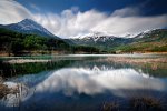
At the end of the neck we find an annealed sign with information on the ascent. We keep ascending having the top on the left side and along the marks. In some places the path is steep. Soon we meet another mountaineering label, which shows us the way to the peaks Vromeri and Koryfi. We will ascend to the left towards the scree slope, that appears in the background. We meet another sign and continue climbing passing over the scree; without snow the ascent is not difficult. This leads to the saddle; we turn left and in a few minutes we are on the summit where we can see Tzoumerka, Avgo, Tsigkori, north Agrafa and other mountains. The climb takes approximately five to six hours, depending on the pace of walking.
Source: www.mountainsgreece.com
Use the map or the alphabet below to find your favorite destination!
Achaea Prefecture
Aegina
Aetoloakarnania Prefecture
Agathonisi
Agistri
Alonissos
Amorgos
Anafi
Andros
Antiparos
Arcadia Prefecture
Argolida Prefecture
Arta Prefecture
Astypalea
Attiki Prefecture
Kalymnos
Karditsa Prefecture
Karpathos
Kasos
Kastelorizo
Kastoria Prefecture
Kavala Prefecture
Kea (Tzia)
Kefalonia
Kerkyra (Corfu)
Kilkis Prefecture
Kimolos
Korinthia Prefecture
Kos
Koufonisi (Ano & Kato)
Kozani Prefecture
Kythira - Antikythira
Kythnos
Samos
Samothrace
Santorini
Schinoussa
Serifos
Serres Prefecture
Sifnos
Sikinos
Skiathos
Skopelos
Skyros
Spetses
Symi
Syros
Would you like to combine skiing in the morning and then go swimming in the afternoon, all in one region? Click to choose your interests and see in which part of Greece you enjoy them. Combinations are endless!
